![](/images/other/stat-length.png)
![Trail Walking La Chapelle-Montligeon - La chapelle Montligeon- En suivant le Tram - Photo](https://media.geolcdn.com/t/1900/400/3f3a383b-7760-4dd5-923e-481206f53d77.jpg&format=pjpeg&maxdim=2)
La chapelle Montligeon- En suivant le Tram
MichelRando7656
User
![Length](/images/other/stat-length.png)
Length
9.2 km
![Max alt](https://static1.geolcdn.com/siteimages/upload/files/1508320355ic_sort_altitude_max_24dp.png)
Max alt
252 m
![Uphill gradient](https://static1.geolcdn.com/siteimages/upload/files/1508320355ic_sort_den_pos_24dp.png)
Uphill gradient
176 m
![Km-Effort](/images/other/stat-length.png)
Km-Effort
11.5 km
![Min alt](https://static1.geolcdn.com/siteimages/upload/files/1508320355ic_sort_altitude_min_24dp.png)
Min alt
156 m
![Downhill gradient](https://static1.geolcdn.com/siteimages/upload/files/1508320355ic_sort_den_neg_24dp.png)
Downhill gradient
167 m
![Boucle](https://static1.geolcdn.com/siteimages/upload/files/16400158638029165_repeat_loop_refresh_sync_direction_icon.png)
Boucle
Yes
Creation date :
2019-09-27 12:35:52.82
Updated on :
2019-09-27 16:21:15.773
![Walking](https://static1.geolcdn.com/sitytour/trail-icons/101.png)
3h44
Difficulty : Easy
![Scan this QR Code to open this trail in the SityTrail application](https://capi.geolives.com/qq0zvz2zws4bq2lad0pu/sitytour/trails/2215564/qr.png?size=200)
FREE GPS app for hiking
About
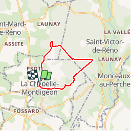
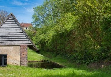
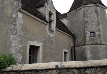
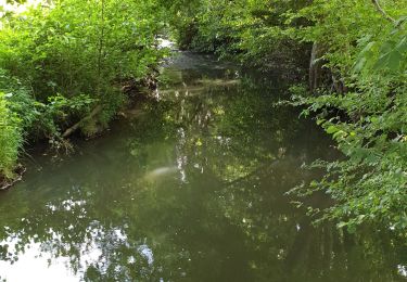
Trail Walking of 9.2 km to be discovered at Normandy, Orne, La Chapelle-Montligeon. This trail is proposed by MichelRando7656.
Description
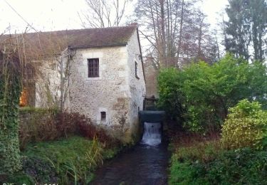
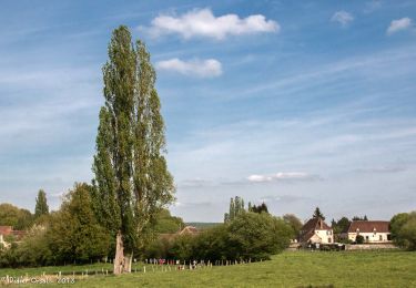
Superbes sentiers de la Forêt de Reno-Valdieu.
Jolies maisons du Perche "Pierres blanches et ocres". On y trouve dans une cave deux alambics très ancien et des bouteilles échantillons de collection d'eau de vie de cidre à ne pas déguster!!
Positioning
Country:
France
Region :
Normandy
Department/Province :
Orne
Municipality :
La Chapelle-Montligeon
Location:
Unknown
Start:(Dec)
Start:(UTM)
326701 ; 5372747 (31U) N.
Comments
Trails nearby
![Trail Walking Longny les Villages - Monceaux au Perche (Boucle) - Photo](https://media.geolcdn.com/t/375/260/ext.jpg?maxdim=2&url=https%3A%2F%2Fstatic1.geolcdn.com%2Fsiteimages%2Fupload%2Ffiles%2F1553511878bg_sport_marche.png)
![Walking Walking](https://static1.geolcdn.com/sitytour/trail-icons/101.png)
Monceaux au Perche (Boucle)
Walking
Easy
(2)
Longny les Villages,
Normandy,
Orne,
France
![](/images/other/stat-length.png)
10.6 km | 13.5 km-effort
2h 30min
![](https://static1.geolcdn.com/siteimages/upload/files/16400158638029165_repeat_loop_refresh_sync_direction_icon.png)
Yes
![Trail On foot Longny les Villages - Attelage - Forêt et Panoramas - forêt de Réno-Valdieu - Photo](https://media.geolcdn.com/t/375/260/db99a0ed-9413-4500-8368-446623bccd86.jpeg&format=jpg&maxdim=2)
![On foot On foot](https://static1.geolcdn.com/sitytour/trail-icons/100.png)
Attelage - Forêt et Panoramas - forêt de Réno-Valdieu
On foot
Easy
Longny les Villages,
Normandy,
Orne,
France
![](/images/other/stat-length.png)
7.6 km | 9.3 km-effort
2h 7min
![](https://static1.geolcdn.com/siteimages/upload/files/16400158638029165_repeat_loop_refresh_sync_direction_icon.png)
No
![Trail Walking La Chapelle-Montligeon - [Itinéraire] Le Mont Ligeon - Photo](https://media.geolcdn.com/t/375/260/ce92da88-fb92-411f-965d-5e4e270d0f79.jpeg&format=jpg&maxdim=2)
![Walking Walking](https://static1.geolcdn.com/sitytour/trail-icons/101.png)
[Itinéraire] Le Mont Ligeon
Walking
Medium
La Chapelle-Montligeon,
Normandy,
Orne,
France
![](/images/other/stat-length.png)
5.1 km | 6.6 km-effort
1h 30min
![](https://static1.geolcdn.com/siteimages/upload/files/16400158638029165_repeat_loop_refresh_sync_direction_icon.png)
Yes
![Trail Walking Cour-Maugis sur Huisne - 12102996-Maison Maugis 22.37 - Photo](https://media.geolcdn.com/t/375/260/ext.jpg?maxdim=2&url=https%3A%2F%2Fstatic1.geolcdn.com%2Fsiteimages%2Fupload%2Ffiles%2F1553511878bg_sport_marche.png)
![Walking Walking](https://static1.geolcdn.com/sitytour/trail-icons/101.png)
12102996-Maison Maugis 22.37
Walking
Medium
(1)
Cour-Maugis sur Huisne,
Normandy,
Orne,
France
![](/images/other/stat-length.png)
22 km | 28 km-effort
Unknown
![](https://static1.geolcdn.com/siteimages/upload/files/16400158638029165_repeat_loop_refresh_sync_direction_icon.png)
Yes
![Trail Walking La Chapelle-Montligeon - La Chapelle-Montligeon - Longny-au-Perche via Bizou 16 km - Photo](https://media.geolcdn.com/t/375/260/5e36f740-ecc7-4760-b425-4f15cc356d54.jpg&format=jpg&maxdim=2)
![Walking Walking](https://static1.geolcdn.com/sitytour/trail-icons/101.png)
La Chapelle-Montligeon - Longny-au-Perche via Bizou 16 km
Walking
Very difficult
La Chapelle-Montligeon,
Normandy,
Orne,
France
![](/images/other/stat-length.png)
15.9 km | 20 km-effort
4h 22min
![](https://static1.geolcdn.com/siteimages/upload/files/16400158638029165_repeat_loop_refresh_sync_direction_icon.png)
No
![Trail Walking La Chapelle-Montligeon - La Chapelle-Montligeon - Moutiers-au-Perche via Bizou 20 km - Photo](https://media.geolcdn.com/t/375/260/4094c967-a97a-44d3-924e-010e9be9049f.jpg&format=jpg&maxdim=2)
![Walking Walking](https://static1.geolcdn.com/sitytour/trail-icons/101.png)
La Chapelle-Montligeon - Moutiers-au-Perche via Bizou 20 km
Walking
Very difficult
La Chapelle-Montligeon,
Normandy,
Orne,
France
![](/images/other/stat-length.png)
20 km | 26 km-effort
5h 33min
![](https://static1.geolcdn.com/siteimages/upload/files/16400158638029165_repeat_loop_refresh_sync_direction_icon.png)
No
![Trail Walking La Chapelle-Montligeon - La Chapelle-Montligeon - Le Mage via Bizou 18 km - Photo](https://media.geolcdn.com/t/375/260/2514d07f-ce42-4914-ba12-eb561f06fea2.jpg&format=jpg&maxdim=2)
![Walking Walking](https://static1.geolcdn.com/sitytour/trail-icons/101.png)
La Chapelle-Montligeon - Le Mage via Bizou 18 km
Walking
Very difficult
La Chapelle-Montligeon,
Normandy,
Orne,
France
![](/images/other/stat-length.png)
17.9 km | 23 km-effort
4h 53min
![](https://static1.geolcdn.com/siteimages/upload/files/16400158638029165_repeat_loop_refresh_sync_direction_icon.png)
No
![Trail Walking Longny les Villages - Monceaux et le Manoir - Photo](https://media.geolcdn.com/t/375/260/2c895f3a-5924-449a-a873-4ad274746411.jpg&format=jpg&maxdim=2)
![Walking Walking](https://static1.geolcdn.com/sitytour/trail-icons/101.png)
Monceaux et le Manoir
Walking
Easy
Longny les Villages,
Normandy,
Orne,
France
![](/images/other/stat-length.png)
7.6 km | 9.6 km-effort
3h 0min
![](https://static1.geolcdn.com/siteimages/upload/files/16400158638029165_repeat_loop_refresh_sync_direction_icon.png)
Yes
![Trail Walking Longny les Villages - Minceaux 2 - Photo](https://media.geolcdn.com/t/375/260/7d79a233-230a-4321-b3f2-9bfbb749ff7a.jpg&format=jpg&maxdim=2)
![Walking Walking](https://static1.geolcdn.com/sitytour/trail-icons/101.png)
Minceaux 2
Walking
Very easy
Longny les Villages,
Normandy,
Orne,
France
![](/images/other/stat-length.png)
10.6 km | 13.5 km-effort
2h 7min
![](https://static1.geolcdn.com/siteimages/upload/files/16400158638029165_repeat_loop_refresh_sync_direction_icon.png)
Yes